Methane (CH4) emission mapping is integral to environmental monitoring of fossil fuel extraction. Cameras operating in the shortwave infrared (SWIR) range have exhibited the ability to detect methane because of its absorption features in the SWIR range. Methane is one of the largest contributors to the greenhouse effect, having a larger impact towards global warming than carbon dioxide (CO2). Tracking sources of methane emissions occurring at production, transmission, and handling natural gas sites help fossil fuel companies pinpoint where potential leaks are located. Quantifying the concentration of emissions from other sources such as livestock, landfills, and wastewater treatment would aid in drafting policies to better reach global climate goals.
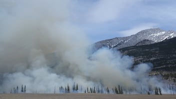
Monitoring emissions continuously plays a crucial role in combating climate change. That's why satellite observation systems rely on SWIR sensors, as they aid in accurately quantifying harmful emissions. The SWIR region of the light spectrum has weaker atmospheric scattering, allowing satellites to penetrate through cloud cover and haze. Methane can be detected within the 1650-2300nm range, which conveniently falls within the SWIR spectrum. Since methane plumes are invisible to the naked eye, imaging systems are pivotal in their detection. As seen in the figure below, HySpex's RGB-SWIR imaging system can detect methane plumes, and as the concentration levels rise, the color darkens accordingly. This imagery provides scientists and engineers with valuable information to quantify and pinpoint methane emissions at their sources, ultimately reducing environmental impact and the costs associated with leakages.
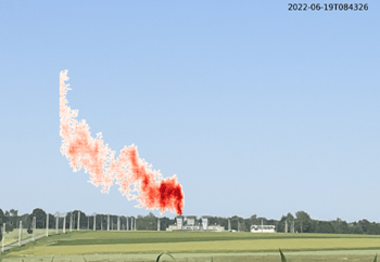
SWIR image of methane emission from a coal mine ventilation shaft. Image provided by HySpex.
Properly measuring methane emissions is incredibly important in mitigating climate change. Remote sensing systems (omitting satellites which are currently employing SWIR vision systems) utilizing SWIR in hyperspectral imagery can be used to detect local sources including livestock farms, landfills, and wastewater treatment facilities that otherwise are not actively monitored. Employing SeeDevice’s QMOS (quantum CMOS) in remote and satellite sensing systems will aid in the efforts of combating climate change because of its ability to be easily integrated into any imaging system and high performance in the SWIR range, improving precision in methane plume detection.